
Lidar-derived carbon estimates in encroaching juniper woodlands
|
Temuulen Sankey, Rupesh Shrestha, Joel Sankey, and Stuart Hardegree Woody encroachment into shrub steppe and grassland ecosystems is a global phenomenon. Juniper encroachment is one of the most prominent changes occurring in rangelands of western North America. The spatial extent of pinyon-juniper woodlands, the third most common vegetation type in the USA, is documented to have increased by an order of magnitude since the mid-19th century. Juniper encroachment can decrease understory vegetation cover and forage, increase soil erosion, alter soil fertility, and deteriorate wildlife habitat. Intensive land treatments, including prescribed burning and cutting, are commonly performed to reduce woody cover. The consequences of both woody encroachment and intensive land treatments for terrestrial carbon (C) stocks are unclear. Woody encroachment may contribute significantly to the global C sink. Large uncertainties exist, however, in global- and continental-scale estimates due to the coarse-scale of the data and models. Intensive land treatment activities can slow down or reverse the accumulation of C stocks that occurs with woody encroachment. Estimates of C accumulation associated with juniper encroachment have varied greatly from -0.11 to 0.22 MgC/ha/yr due to the methods and scale of analysis. Previous optical and multispectral remote-sensing approaches provide only a 2-dimensional measurement of juniper cover change. To improve estimates of aboveground woody C storage, we test a new technique using high-resolution, 3-dimensional lidar measurements of individual juniper trees. In this study, we test an object-based tree crown delineation approach, with segmentation followed by local-maxima to detect individual tree crowns, and compute the metrics from the lidar points within each tree crown area. This approach of computing metrics directly from the lidar point cloud, rather than from an interpolated raster surface, is expected to improve lidar-based tree biomass estimation. | 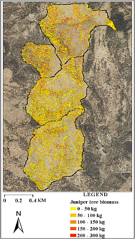 A total of 60,628 individual juniper trees were identified and their aboveground biomass estimated using lidar point cloud data in the South Mountain watershed study area. |
Field-measured tree age data indicate that the western juniper communities in the study area of South Mountain watershed in southwestern Idaho are characteristic of post-settlement expansion communities. Our results indicate that lidar-derived measurements produced accurate estimates of juniper tree height, canopy cover, and density. Furthermore, individual tree and landscape-scale biomass can be quantified with lidar, which greatly extends the ability to accurately classify successional stages of juniper encroachment relative to previous 2-dimensional remote sensing procedures. Our results indicate that above-ground storage of C is enhanced during the transition from phase I to phase III of successional stages of juniper encroachment; phase III can store almost three times the aboveground C as encroachment phase I.